빠르게 변화하는 드론 산업에서 연방 규정을 준수하고 첨단 기술을 사용하는 것은 경쟁력을 유지하기 위해 필수이다. 위치 인텔리전스 분야의 글로벌 리더인 에스리(Esri) (https://cts.businesswire.com/ct/CT?id=smartlink&url=https%3A%2F%2Fwww.esri.com%2Fen-us%2Fabout%2Fabout-esri%2Foverview&esheet=54210699&newsitemid=54210699010&lan=en-US&anchor=Esri&index=1&md5=f76b2c0f12e8b1fbc3cefc2a9310c763)가 이제 에스리의 ArcGIS 플라이트(ArcGIS Flight) 애플리케이션과 통합되는 최초의 블루 UAS(Blue USA) 승인 및 미국 국방수권법(National Defense Authorization Act, NDAA) 준수 드론인 ‘아스트로 맥스(Astro Max)’를 지원한다.
에스리의 파트너인 프리플라이 시스템스(Freefly Systems)가 개발한 아스트로 맥스는 미국산 드론으로, NDAA와 국방혁신단(Defense Innovation Unit, DIU)의 블루 UAS 이니셔티브의 엄격한 보안 및 성능 기준을 충족한다. 이 작고 강력한 산업용 드론은 ArcGIS 플라이트를 통해 정부 및 기업 사용자의 역량을 강화한다.
ArcGIS 플라이트의 수석 제품 엔지니어인 브렌트 피어스(Brent Pierce)는 “이번 통합을 통해 우리는 연방 고객의 요구를 충족할 뿐만 아니라 잠재적인 연방 규제보다 앞서 나갈 수 있게 되었다. 이처럼 선제적인 조치는 사용자의 성공을 위한 에스리의 노력을 강화하고, 드론 매핑 업계에 드론 운영을 위한 원활하고 안전한 솔루션을 제공함으로써 업계에서 에스리의 리더십을 공고히 한다”고 말했다.
특히 미국 정부를 위해 임무를 수행하는 UAS 조종사는 ArcGIS 플라이트 모바일 앱 내에서 드론을 자율적으로 비행시키고, 고품질 드론 이미지를 캡처하고, 상황적 인식을 향상할 수 있다. 또한 주요 이해관계자와 비행 정보를 쉽게 공유하고 위치 및 방향 데이터를 포함한 지리 공간 비디오를 수집할 수 있다. 이처럼 간소화된 접근 방식은 운영 효율성을 높이고, 정부 고객이 크리티컬 미션을 위한 보안 통합 솔루션을 확보할 수 있도록 지원한다.
에스리의 아스트로 맥스 지원은 드론 업계에서 중요한 이정표이다. 정부기관과 조직에 최고 수준의 보안 및 규정 준수 기준을 충족하는 신뢰할 수 있고 안전한 고성능 드론 솔루션을 제공하기 때문이다.
ArcGIS 플라이트에 대한 보다 자세한 사항은 esri.com/arcgis-blog/products/flight/imagery/introducing-arcgis-flight/ (https://www.esri.com/arcgis-blog/products/flight/imagery/introducing-arcgis-flight/)에서 확인할 수 있다.
에스리 소개
지리 정보 시스템(GIS) 소프트웨어, 위치 인텔리전스 및 매핑 분야의 글로벌 시장 리더인 에스리(Esri)는 고객이 데이터의 잠재력을 최대한 활용하여 운영 및 비즈니스 결과를 개선할 수 있도록 지원한다. 1969년 미국 캘리포니아 레드랜즈에서 설립된 에스리 소프트웨어는 포춘 선정 500대 기업, 정부 기관, 비영리 기관 및 대학을 포함하여 전 세계 수십만 개의 조직에 배포된다. 에스리는 6개 대륙의 100개 이상의 국가에서 지역 사무소, 국제 대리점 및 현지 지원을 제공하는 파트너를 보유하고 있다. 에스리는 지리 공간 기술 및 분석에 대한 선구적인 노력을 통해 세계에서 가장 복잡한 문제를 중요한 위치 컨텍스트에 배치하여 해결하기 위해 지리적 접근 방식을 활용하는 가장 혁신적인 솔루션을 설계한다. 웹사이트: esri.com
Copyright © 2025 Esri. 모든 권리 보유. Esri, Esri 지구 로고, ArcGIS, The Science of Where, esri.com 및 @esri.com은 미국, 유럽 공동체 또는 기타 특정 관할권에서 Esri의 상표, 서비스 마크 또는 등록상표이다. 여기에 언급된 기타 회사 및 제품 또는 서비스는 해당 상표 소유자의 상표, 서비스 마크 또는 등록상표일 수 있다.
In the fast-paced drone industry, compliance with federal regulations and the use of advanced technology are essential for staying competitive. Esri (https://cts.businesswire.com/ct/CT?id=smartlink&url=https%3A%2F%2Fwww.esri.com%2Fen-us%2Fabout%2Fabout-esri%2Foverview&esheet=54210699&newsitemid=20250220665340&lan=en-US&anchor=Esri&index=1&md5=f76b2c0f12e8b1fbc3cefc2a9310c763), the global leader in location intelligence, is now supporting the Astro Max drone, the first Blue UAS cleared and NDAA-compliant drone to integrate with Esri’s ArcGIS Flight application.
Developed by Esri partner Freefly Systems, the Astro Max is an American-made drone that meets the rigorous security and performance standards of the National Defense Authorization Act (NDAA) and the Defense Innovation Unit’s (DIU) Blue UAS initiative. This compact and powerful industrial drone enhances the capabilities of government and enterprise users with ArcGIS Flight.
“With this integration, we’re not only meeting federal customers’ demands but also staying ahead of potential federal regulations,” said Brent Pierce, lead product engineer for ArcGIS Flight. “This proactive step reinforces Esri’s commitment to our users’ success and solidifies our leadership in the drone mapping industry by providing them with a seamless and secure solution for drone operations.”
Within the ArcGIS Flight mobile app, UAS pilots, especially those flying missions for the U.S. government, can fly drones autonomously, capture high-quality drone imagery, and enhance situational awareness. They can also easily share flight information with key stakeholders and collect geospatial video, which includes location and orientation data. This streamlined approach boosts operational efficiency and ensures that government customers have a secure and integrated solution for their critical missions.
Esri’s support for the Astro Max is a major milestone in the drone industry. It provides government agencies and organizations with a trusted, secure, and high-performance drone solution that meets the highest standards of security and compliance.
To learn more about ArcGIS Flight, visit esri.com/arcgis-blog/products/flight/imagery/introducing-arcgis-flight/ (https://www.esri.com/arcgis-blog/products/flight/imagery/introducing-arcgis-flight/).
About Esri
Esri, the global market leader in geographic information system (GIS) software, location intelligence, and mapping, helps customers unlock the full potential of data to improve operational and business results. Founded in 1969 in Redlands, California, USA, Esri software is deployed in hundreds of thousands of organizations globally, including Fortune 500 companies, government agencies, nonprofit institutions, and universities. Esri has regional offices, international distributors, and partners providing local support in over 100 countries on six continents. With its pioneering commitment to geospatial technology and analytics, Esri engineers the most innovative solutions that leverage a geographic approach to solving some of the world’s most complex problems by placing them in the crucial context of location. Visit us at esri.com.
Copyright © 2025 Esri. All rights reserved. Esri, the Esri globe logo, ArcGIS, The Science of Where, esri.com, and @esri.com are trademarks, service marks, or registered marks of Esri in the United States, the European Community, or certain other jurisdictions. Other companies and products or services mentioned herein may be trademarks, service marks, or registered marks of their respective mark owners.
View source version on businesswire.com: https://www.businesswire.com/news/home/20250220665340/en/
 파퓰러스, 펜트리스 아키텍츠 인수로 글로벌 항공 포트폴리오 확대
스포츠 및 엔터테인먼트 행사장을 전문으로 다루는 세계적으로 유명한 디자인 회사 파퓰러스(Populous)는 오늘 덴버에 본사를 둔 펜트리스 아키텍츠(Fentress Architects)의 인수를 발표했다. 펜트리스 아키텍츠는 상징적인 항공 프로젝트와 컨벤션 센터, 박물관, 정부 시설을 포함한 유명 공공 건물 분야의 글로벌 리더이다. 이 전략적 인수를 통해 건축계에서 가장 존경받는 두 이름이 하나로 합쳐져, 기억에 남는 경험을 디자인하는 파퓰러스의 탁월한 전문성과 항공, 도시 및 문화 랜드마크 분야에서 수상 경력에 빛나는 펜트리스의
파퓰러스, 펜트리스 아키텍츠 인수로 글로벌 항공 포트폴리오 확대
스포츠 및 엔터테인먼트 행사장을 전문으로 다루는 세계적으로 유명한 디자인 회사 파퓰러스(Populous)는 오늘 덴버에 본사를 둔 펜트리스 아키텍츠(Fentress Architects)의 인수를 발표했다. 펜트리스 아키텍츠는 상징적인 항공 프로젝트와 컨벤션 센터, 박물관, 정부 시설을 포함한 유명 공공 건물 분야의 글로벌 리더이다. 이 전략적 인수를 통해 건축계에서 가장 존경받는 두 이름이 하나로 합쳐져, 기억에 남는 경험을 디자인하는 파퓰러스의 탁월한 전문성과 항공, 도시 및 문화 랜드마크 분야에서 수상 경력에 빛나는 펜트리스의
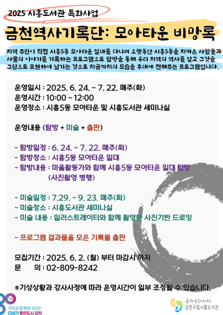 금천구립시흥도서관, 주민이 직접 역사를 기억하는 ‘금천역사기록단 : 모아타운 비망록’ 운영
금천문화재단(대표이사 서영철) 금천구립시흥도서관은 오는 6월 24일부터 금천구 지역의 모습을 기록하고 주민의 목소리를 담는 ‘금천역사기록단 : 모아타운 비망록’을 운영한다고 밝혔다. 이번 사업은 금천구립시흥도서관의 특화사업으로 지역을 탐방하며 관찰하고 기록해 미술작품으로 표현하고 이를 엮어 책으로 발간하는 과정이다. 올해의 주제는 ‘시흥 5동 모아타운’이다. ‘모아타운’은 서울시에서 진행하는 소규모 저층 주택 정비 사업으로, 시흥 5동 일대도 해당 사업 대상지이다. 해당 지역 정비를 앞두고 오랜 기간 구민들의 삶의 터전이었던 시흥5
금천구립시흥도서관, 주민이 직접 역사를 기억하는 ‘금천역사기록단 : 모아타운 비망록’ 운영
금천문화재단(대표이사 서영철) 금천구립시흥도서관은 오는 6월 24일부터 금천구 지역의 모습을 기록하고 주민의 목소리를 담는 ‘금천역사기록단 : 모아타운 비망록’을 운영한다고 밝혔다. 이번 사업은 금천구립시흥도서관의 특화사업으로 지역을 탐방하며 관찰하고 기록해 미술작품으로 표현하고 이를 엮어 책으로 발간하는 과정이다. 올해의 주제는 ‘시흥 5동 모아타운’이다. ‘모아타운’은 서울시에서 진행하는 소규모 저층 주택 정비 사업으로, 시흥 5동 일대도 해당 사업 대상지이다. 해당 지역 정비를 앞두고 오랜 기간 구민들의 삶의 터전이었던 시흥5
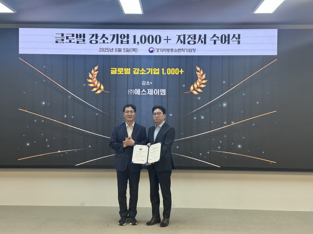 에스제이엠 ‘2025년 글로벌 강소기업 1000+ 프로젝트’에서 ‘강소+’ 단계 최종 선정
자동차 부품 전문기업 에스제이엠이 중소벤처기업부가 주관하는 ‘2025년 글로벌 강소기업 1000+ 프로젝트’에서 ‘강소+’ 단계에 최종 선정됐다. 이에 6월 5일 경기지방중소벤처기업청에서 지정서와 현판을 수여받았다. ‘글로벌 강소기업 1000+ 프로젝트’는 세계 시장에서 경쟁력 있는 기술과 제품을 보유한 성장 가능성이 높은 수출 중소기업을 발굴해 글로벌 수출 선도 기업으로 육성하고자 마련된 정부의 대표 중소기업 지원 사업이다. 선정은 기업의 성장성, 혁신성, 글로벌 진출 역량 등 엄격한 기준을 바탕으로 이뤄지며, 국내외 시장에서 기
에스제이엠 ‘2025년 글로벌 강소기업 1000+ 프로젝트’에서 ‘강소+’ 단계 최종 선정
자동차 부품 전문기업 에스제이엠이 중소벤처기업부가 주관하는 ‘2025년 글로벌 강소기업 1000+ 프로젝트’에서 ‘강소+’ 단계에 최종 선정됐다. 이에 6월 5일 경기지방중소벤처기업청에서 지정서와 현판을 수여받았다. ‘글로벌 강소기업 1000+ 프로젝트’는 세계 시장에서 경쟁력 있는 기술과 제품을 보유한 성장 가능성이 높은 수출 중소기업을 발굴해 글로벌 수출 선도 기업으로 육성하고자 마련된 정부의 대표 중소기업 지원 사업이다. 선정은 기업의 성장성, 혁신성, 글로벌 진출 역량 등 엄격한 기준을 바탕으로 이뤄지며, 국내외 시장에서 기
 에스티 로더 컴퍼니즈, 리사 세퀴노를 메이크업 브랜드 클러스터 사장으로 임명
에스티 로더 컴퍼니즈(Estée Lauder Companies Inc.)(뉴욕증권거래소: EL)가 리사 세퀴노(Lisa Sequino)를 메이크업 브랜드 클러스터 신임 사장으로 임명한다고 발표했다. 이 직책은 메이크업의 전략적 방향과 글로벌 성장을 주도하고 M·A·C, 바비 브라운(Bobbi Brown), 투페이스드(Too Faced), 스매쉬박스(Smashbox) 및 글램글로우(GLAMGLOW)를 포함한 회사 메이크업 브랜드 포트폴리오를 총괄하는 역할이다. 세퀴노는 수석부사장 겸 최고브랜드책임자인 제인 헤르츠마크 후디스(Jane
에스티 로더 컴퍼니즈, 리사 세퀴노를 메이크업 브랜드 클러스터 사장으로 임명
에스티 로더 컴퍼니즈(Estée Lauder Companies Inc.)(뉴욕증권거래소: EL)가 리사 세퀴노(Lisa Sequino)를 메이크업 브랜드 클러스터 신임 사장으로 임명한다고 발표했다. 이 직책은 메이크업의 전략적 방향과 글로벌 성장을 주도하고 M·A·C, 바비 브라운(Bobbi Brown), 투페이스드(Too Faced), 스매쉬박스(Smashbox) 및 글램글로우(GLAMGLOW)를 포함한 회사 메이크업 브랜드 포트폴리오를 총괄하는 역할이다. 세퀴노는 수석부사장 겸 최고브랜드책임자인 제인 헤르츠마크 후디스(Jane
 6월9일 오늘의 역사 – 나치의 보복, 이한열 열사 사망, 유고슬라비아와 NATO 평화협정, 독도의 달 조례. 홍콩 민주화 운동
 AI 수출컨설던트
 45년생 꼼꼼한 국어선생님이 평생 다듬고 가려 뽑은 순우리말사전

 목록
목록